Ever since our family stayed at the
Lodge in
Zion National Park in 2003, this park has been one of my favorites. It's like a smaller, redder version of Yosemite… amazingly steep canyon walls carved by rivers and creeks, but these are red sandstone, not gray granite. It's one of the overlooked gems of the Colorado Plateau due to other more popular parks nearby like the Grand Canyon and Arches.
Like most of our national parks, you only see a tiny fraction of the beauty of the place from the paved roads. The trails of the backcountry are the only way to experience the wonders of a place like Zion.
To see my complete slideshow in a new window, click here (click on "options" in bottom right corner to turn on/off descriptions of pictures).
Driving Day (Wed, June 11): 450 miles of drivingI drove to Zion and got there in time to pick up my permits and exchange them for better campsite locations. I
camped just outside the park next to the Virgin River.
Hiking Day 1 (Thurs, June 12): 6 miles of backpacking and 8 miles of trail runningI parked my car at the East Entrance and then as arranged,
Red Rock Shuttle drove me 54 miles to Lee's Pass at the far northwest corner of the park at Kolob Canyons. Gordon (the driver) was a nice guy who knew lots of stories about southern Utah. As he drove off, I thought, "Ok,
I'm out here by myself and
47 miles from my car. Better git 'er dun!"
I backpacked 6 miles down the La Vernkin Creek trail. The trail meanders along and frequently across La Vernkin Creek to the campsites. It took only a couple of hours to arrive at my campsite since it was almost all downhill, even though I stopped often to take pictures. Photographing Zion was a futile attempt to capture the beauty of this place and to try to bring it home to savor.

After setting up camp under a big oak tree at La Vernkin campsite #9. I decided to go for a trail run to see some nearby sights off the main trail. I felt light as a feather without my pack! First, I ran about a mile up to see
Kolob Arch. With a span of 287', it is allegedly the second largest natural arch in the world (second only to Landscape Arch in Arches National Park). It's the highlight of this corner of Zion which most hikers in these parts make as their main destination. Due to the time of day with the sun setting behind it, I never could position myself for a decent photograph of the arch (the photo here is not mine). But it was stunning to see in person. The frogs in the creekbed seemed to agree as they croaked a loud chorus upon my approach.
Next I set out to find a waterfall I thought was up
Willis Creek. I kept running up the creekbed and across the creek. A small rattlesnake greeted me as I passed by. I thought WWJMD? (What would John Muir do?) So I left the critter alone and marked the trail with pinecones so I knew where to be extra cautious on my return through there an hour later.
I had run a few miles up the creek and it was starting to get late so disappointedly I decided to turn around and head back to camp. I realized afterward that I missed the falls because they were up Bear Trap Canyon which splits off of Willis Creek. Oh well. It still was fun going for a trail run up a creek and through the deep and rarely explored canyons of Zion.
Later that night, I was sitting next to La Vernkin Creek eating dinner when I had visitors. A
duck and her seven little ducklings swam and waddled by. A few hours later, I was lying in my tent about dusk when I heard something walking around outside. It sounded too big to be a squirrel but too small to be a mountain lion. It was a
wild turkey with three little chicks in tow. It was nice for my neighbors to bring their families by.
Hiking Day 2 (Fri, June 13): 26 miles of backpackingI slept hard Thursday night and got up at first light and was on the trail early. I knew I had to make good time because this was my longest leg of my trip.
First, I backpacked a mile up La Vernkin Creek trail to the Hop Valley trail. The Hop Valley trail began with a steep climb with switchbacks up to the top of a pass where I could see for several miles up the wide sandy plain known as Hop Valley. The creek was about ten yards wide and no more than about 3" deep. Hiking the 6½ miles through Hop Valley was like hiking on the beach. My feet sank low in the loose fine sand (especially with an extra 45 lbs. on my back). It made for some slow progress, and I found that I was carrying a good bit of the trail with me… in my shoes.

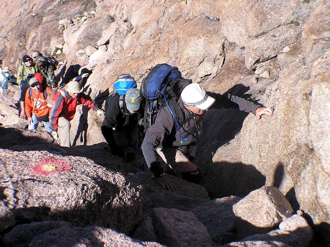
A few miles up the creek, the trail seemed to split and go up a steep hillside through some brush. I stood there for several minutes trying to determine which direction was actually the main trail. My detailed map didn't seem to indicate any trail splitting off. Since it looked more well worn to go uphill, I figured the trail must be bypassing some kind of steep obstacle up the creek. I progressed up the steep hill and through low-hanging branches. Soon I was questioning how this could be the main trail, but there was lots of horse manure functioning like bread crumbs (ok, I admit that's a gross analogy) leading me on higher and further through the brush. I certainly wasn't the only man (or beast) that had come this way. Finally, I was getting frustrated with the relentless scratching of this thick underbrush and I decided to cut across back to the other trail down below in the creek bed. "Ruh roh, Scraggy" I thought as I now stood at the top of a 40' ravine looking at the trail far below.
I stood there for a few minutes weighing my options. Backtrack? No, I didn't have time to waste on my longest hiking day. Lower my pack down and then climb down? No, my pack and possibly myself would get smashed on the boulders below. Search for another way down? Yes, not too far away, I found a place where many other frustrated off-trail hikers had descended to the true trail below. I've never been happier to be back on the main trail.
Soon I had made it to the Hop Valley trailhead. Wow, a latrine (who'da thunk that would be a step up for bathroom facilities) complete with anti-bacterial soap (what a novel idea)! I sat in the shade of the trees and ate lunch.
Next I headed across
the Connector Trail. These 4 miles led across softly rolling hills with mostly low brush but some trees. Then came the 5 miles known as Wildcat Canyon trail. This was a wide trail which offered trees for shade now that the day was getting hot. I passed a group of about 15 people who were out on a short day-hike to Northgate Peaks. They looked at me rather odd since I was carrying more gear than all of them combined. I guess they didn't realize that all these smaller shorter trails in Zion could be combined into one long Trans-Zion expressway.
Finally, I came to the West Rim trail. This (combined with the Telegraph Canyon trail) would be my route for what I thought would be the final 8½ miles of the day. After ¾ of a mile, I came across the sign for what would be my last water source for the rest of the day… Sawmill Spring. The spring was about a third of a mile down a hill off the trail. I wasn't even sure if it was running or not. I figured, I'd better fill up with water so I set my pack under a large pine tree and headed down the trail with my camelbak bladder and my water-filter pump. The spring was a tiny bubbling pool of water about the size of the spurt of oil that Jed Clampett had shot out of the ground. Even though the spring sat in the hot afternoon sun, the water was refreshingly cold and tasted oh so good!
By this point of the afternoon, I was counting down the miles (or more rightly the minutes) until I came to the Telegraph Canyon trail which served as a 1½-mile shortcut to my campsite. Unfortunately, there was a long steep climb upward to that much anticipated junction… and when I got there I was rudely greeted with an unexpected sign: "
TRAIL CLOSED due to downed trees and erosion." I wasn't too excited about this little detour. After hiking 23 miles with a 45-pound pack to get to this point, I just collapsed under a tree and pondered that sign. Instead of hiking 1.8 miles down Telegraph Canyon trail, I now had to hike 3.2 miles continuing on West Rim trail.
Even though I really wasn't in the mood to add any extra miles to my hike that day, I must admit the
views from the West Rim trail were stunning. Most of the way, I was looking down on countless canyons as far as one could see. When I did arrive at
my campsite (West Rim #1), I just dropped my pack and laid flat on my back for 15-20 minutes. I've run marathons in rugged places like Pikes Peak, Crater Lake, and Death Valley before, but it's been a long time since I've been that exhausted. Running 26 miles free-spirited and unencumbered is one matter, but hiking 26 miles with a full pack is a whole other matter. I realized 26 miles of backpacking is about my limit for one day. That's good to know.
After inhaling a tasty dinner of rice, beef jerky, and an orange for dessert (all of which pretty much vaporized in my mouth), I insisted that my tired legs take me and my water filter about a quarter mile further down the trail to Cabin Spring (the reason I selected this campsite) to load up on water. That would be one less thing to do in the morning.
That night I had visitors again, but these were not as welcome. Seemingly every mosquito on that side of the park smelled fresh blood. And they congregated on the screen of my tent. I was treated to a gorgeous sunset out the side of my tent as night fell, and my hungry little visitors returned in the morning for sunrise to see if I wanted to come out and play.
Hiking Day 3 (Sat, June 14): 16 miles of backpacking and 450 miles of drivingI went to bed Friday night wondering what my legs would feel like in the morning. I was afraid they might stage a revolt and self-amputate themselves if I tried to walk any further. But I was pleasantly surprised to find my legs awoke refreshed and up for another big day of hiking.
Saturday would be a shorter day in terms of mileage, but it was a day of bigger climbs. I'd be hiking down into the heart of the main valley thousands of feet below and then back up and out of the canyon up the steep walls, up to the East Rim, and on over to the East Entrance.
I started early again, and I proceeded two miles down the West Rim trail
to Scout's Lookout. The morning sunrise over the canyons adjacent to the trail was spectacular. It was odd to arrive at Scout's Lookout by mostly going downhill. I had been here three years before after running the St. George Marathon. Scout's Lookout is the last stop on the main trail up from the floor of Zion to Angel's Landing. At Scout's Lookout, there's only the final strenuous and rather exposed ½-mile climb up to the top of Angel's Landing, one of the supreme highlights of Zion National Park. Like I said, I had been here before, but on that afternoon in October 2005, my legs were too tired to go any further after running 26 miles that morning for my first BQ (Boston-qualifier).

But this morning, my legs were fresh so I stashed my pack (no need to take that to the top!) and set off with only my camera to conquer
Angel's Landing. Again, I felt light as a feather as I quickly
climbed the final 500' to the top… and it is a climb, often on all fours and often with no more than a few feet of room to spare with the valley floor 2,000' directly below. There were a few early-risers who were already up on top savoring
the amazing views of the valley in all directions. But what distracted my attention was the sight of the steep switchbacks on the east canyon wall that I knew I'd have to ascend in an hour or two. Normally, I'd relax and spend some time on a magnificent summit like this, but I'd better get going if I wanted to climb those switchbacks in the shade of the canyon wall.
So I darted back down to my pack and quickly descended to the valley floor. I passed dozens and dozens of hikers who again gave me strange looks as I descended this popular trail with a full pack. As I approached the footbridge crossing the Virgin River, a
herd of five deer waded out into the river. I pointed these out to hikers I passed, most of whom were too oblivious to have noticed for themselves the wildlife right beside them.
I crossed the footbridge at the Grotto and headed 1½ miles up the main road to Weeping Rock. It felt odd to be backpacking on a paved road, but the only vehicles were the park shuttle buses ferrying visitors to the various highlights of the valley floor. Would I ease my feet and ride the bus to my next trail junction? Nah, that would be cheating. So I just waved a friendly wave as I headed up the road… and I spared the bus riders the strong scent of "Ode of Wilderness."
About ten minutes up the road, a shuttle bus passed, and no sooner had it done so and a big buck jumped out in the road about 10 yards ahead of me. He just looked at me cock-eyed as if to say, "You're not supposed to be there! The bus just passed. What are you doing here?" And then he dashed off the side of the road to his friends below in the river.
Weeping Rock serves as the trailhead for the East Rim trail and Observation Point. Five years ago, I had gone this way before. I had power-hiked the four-mile trail to Observation Point… but I was carrying only a tiny day pack with a small amount of water that day. Today would be different.
Fortunately, I was graced with the cool shade of the shadows from the east canyon wall as I hiked two miles and up several thousand feet in elevation. I felt like a tractor-trailer in low gear as I ascended the reasonable grade of the switchbacks. Above the switchbacks, for a short while the trail meanders through and above several
mesmerizing slot canyons that are so characteristic of Zion. I couldn't help but think, I can't wait to come back here sometime and hike the Narrows (the most famous slot canyon in Zion) with my wife and kids. That's the most popular hike in the park, and something that would interest them much more than a 3-day, 47-mile backpacking trip.
After the trail for Observation Point split from my route on the East Rim trail, I rudely discovered that I had a lot more elevation to gain. And it was hot. The sun had been scorching these shadeless slabs of sandstone that now served as my path. The route was hot, steep, and relentless. The only consolation for this draining grind was that the temperatures would get cooler as I ascended in elevation… supposedly, but I didn't seem to feel it. Across these rocks, the path was obscure and difficult to trace, but cairns had been built to dot the route as trail markers.
I was sweating profusely as I sucked in hot dry air and guzzled cold water while laboring with my pack up to and on top of the East Rim itself. The trail leveled off and now provided the cool shade of large trees that adorned the edge of the canyon rim. Two days ago, I was shutter happy as I paused to snap up pictures of canyons like these. But now, I knew I was on the final leg of my journey and within a couple of hours of my car so even the beauty of the East Rim couldn't slow me down much.
After traversing a large treeless meadow, I found myself at Stave Spring, the last water source on my hike. I thought I probably had enough water to make it to the car with no problem, but I had used so much already I figured it wouldn't hurt to fill up. So I did.
It was a good decision because the rest of the trail was a shadeless descent on a wide barren trail that was baking in the afternoon sun. I applied copious amounts of sunscreen and tucked a bandana under my hat to serve as a shade for the back of my neck. Soon down the road, I was treated to the trickle of cold water down the back of my pants. I thought, "That feels good! No, wait a minute? I'm not supposed to be feeling that!" I discovered the tubing of one of my camelbak bladders had disconnected and drained itself in my backpack. Nothing I could do about it now… and I'm glad I had second one in there.
Since there's no mile markers on trails like these, I was calculating in my head my estimated time of arrival for the last five miles of the hike (based on my pace from the previous days). Two low-flying vultures circled overhead. I thought, that's not a good sign. Good thing I'm not superstitious. It didn't dawn on me til afterward that yesterday was Friday the 13th.
Slowly the miles ticked off… they seemed extremely drawn out since I'm used to running... but without a pack. It was as if time was in slow motion. But I was making progress. No sooner had I calculated that I probably had one mile to go than I rounded the bend and there was my car! "
Yes!" I shouted and I've never been happier to know I had misjudged my finish!
I wasted no time as I loaded up my gear and headed off down the road. I had thoroughly enjoyed Zion, but I was ready to head for home. Tomorrow was Father's Day and I really wanted to get home to see my wife and kids that night. And seven hours later I did. It was an awesome, awesome backpacking trip, but it was good to be home… back to the land of soft beds, indoor plumbing and running water.
 But for the last weekend of June 2008, White Mountain was the perfect peak for my son and me. We were looking for a high, nearby (relatively speaking) peak where we could do his 4th grade science project. For him, it would be a tough but reasonable hike to do... his longest and highest hike yet... and his first 14er. (Click here for complete slideshow of pictures.)
 On Friday, we drove 5 hours up 395 to Big Pine and then on up Hwy 168 and White Mtn road. We got to the trees late in the afternoon, but still with plenty of time to do the 4-mile walk on the Methuselah Grove trail. The path leads you to the grove where many 3,000+ year old trees still stand, more than 20 of which are 4,000+ years old. Of course, the Methuselah Tree itself is not identified to protect it from the public, but we sure had fun trying to guess which one it might be. Of course, the great irony of the bristlecone pines is that in 1964 a grad student studying the trees cut down an old one on Wheeler Peak (in Nevada) only to discover later that he had cut down the oldest one! (The Prometheus Tree dated to be at least 4,862 years old, possibly older.)
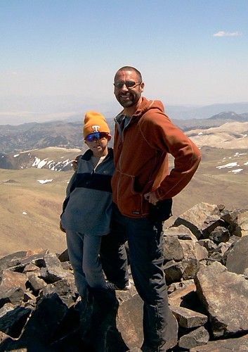 By the time we summitted, word had already spread among those on top that a 9yo boy was on his way up. When we got there, everyone was congratulating him and raving about his hiking ability. And he loved every minute of it.


