At 14,259’, Longs Peak (for more info from SummitPost.org, Wikipedia, NPS, or RockyMountainNews) is the 15th highest 14er in the state of Colorado (of 54 such peaks). It’s the highest point in the Rocky Mountain National Park and the northernmost 14er in the Rocky Mountains in the state of Colorado (and the only 14er north of I-70).
Longs Peak can easily be spotted from Estes Park and even Boulder (30 miles south). The peak is named after Major Stephen Long who explored the area in the 1820s. The first recorded summit of the peak was the surveying party of John Wesley Powell in 1868. Longs Peak is also the peak depicted on the 2006 Colorado state quarter.
Summiting Longs Peak is never a sure thing. There are quite a few variables that can thwart the best attempts at the peak…
- Weather: summer afternoon thunderstorms are a regular occurrence in the Colorado high country. Many of the deaths on Longs Peak have been due to lightning strikes. It’s best to be off the exposed high places by early in the afternoon.
- Snow and Ice: the presence of snow and ice on the narrow passages on the west and south sides of the mountain make even the Keyhole Route to be a technical climb requiring crampons and ice axe until mid-July.
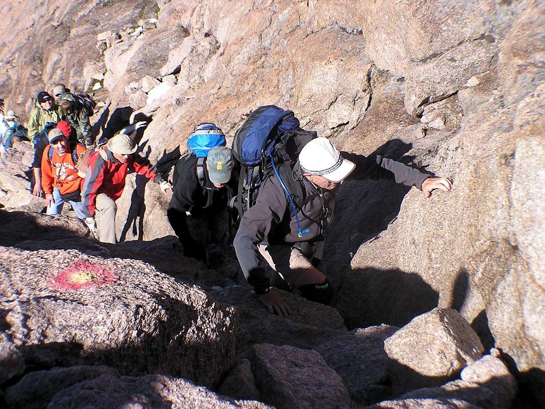
- Crowds: since the Keyhole Route is the most popular hike of any Colorado 14er, in the summertime this peak can be overcrowded with people... sometimes as many as 100 at a time on the peak at once. The NPS estimates that 15,000 climb Longs Peak each year, most between mid-July and late-September. This creates long lines cueing up to go single file through the treacherous narrow passages ascending and descending. The crowds can also make securing a campsite quite difficult in the Boulderfield or anywhere near the TH (important for an early start).
Since the 1800s, there have been 55 recorded deaths on Longs Peak from such things as lightning, hypothermia, and falls due to winds, ice, and rocks breaking loose.
Longs Peak has been high on my to-do list for at least five years. Every time I visit Colorado, I’ve dreamed about summiting this mountain, but the timing and conditions have not been right… until yesterday, Friday the 13th of all days.
The Keyhole Route
The Keyhole Route is the “easiest” route to Longs Peak, but it is far from easy. It is not simply a hike but a strenuous trek across 7.5 miles of rough terrain and up 4800’ in elevation. The first 5.9 miles are a class-1 hike from 9400’ at the TH to 12,750’ at the “Boulderfield.” The Boulderfield ascends upward until you reach a notch in the mountain appropriately called “the Keyhole” at 13,150’. At the Keyhole, the route becomes a class-3 climb across narrow passages and up steep ravines for the last 1.3 miles of the trek.
The Keyhole provides access between the east and west sides of the mountain and the first sights of Glacier Gorge thousands of feet below. From the Keyhole to the summit, the route is marked with a series of red and yellow bull’s eyes painted on the rocks. From the Keyhole, the route traverses horizontally across a series of narrow ledges for roughly 500 yards until you come to “the Trough.”
The Trough (up and down) is a long, steep couloir which ascends skyward to 13,850’. At the top of the Trough, climbers have to carefully maneuver around a large impeding boulder to come around to the south side of the mountain and in view of the valley thousands of feet below.
The route then traverses across an exposed ledge appropriately called “the Narrows.” After the Narrows, the climb ascends sharply upward for 300’ in a couloir called “the Homestretch.” At the top of the Homestretch, you climb over a rock and surprisingly are suddenly in full view of the relatively flat summit for the first time.
My Ascent of Longs Peak
I arrived at the campground at the TH late on Thursday afternoon and was surprised to find plenty of campsites still available. I have to thank the NPS for this. They had a warning posted stating that Longs Peak was still a technical climb requiring crampons and ice axe due to snow and ice. But I knew from recent online reports and talking with hikers in the campground that snow and ice were not a problem on the Keyhole Route. Thanks to the NPS warning, I wouldn’t have to battle the crowds going to the top.
I wasn’t sure how long it would take me to summit this mountain, but I definitely wanted to be back below treeline before afternoon thunderstorms rolled in. So I decided to start out early.
I was on the trail at 4:45am with headlamp on. I passed individuals and groups who had started out earlier as I power-hiked upward through the trees and through the barren rocks above treeline. The sunrise to the east was gorgeous. Soon I found myself at the unmistakable place called the Boulderfield. I quickly hopped across the rocks and was at the Keyhole at 7:00am. Then I got scared. You have to understand that I’m a hiker, not a climber.
As I peered through the Keyhole, before me for the first time I saw the beginning of the narrow ledges I had read about. Underneath me was the beautiful Glacier Gorge dotted with mountain lakes thousands of feet below. A female climber who looked like she knew what she was doing (at least she had a rock climber’s helmet on) was the only person on the route ahead of me.
So I gritted my teeth and started off after her. I was thinking it would be wise to follow someone who knew what they were doing (or at least looked like she knew what she was doing). I told myself, just don’t look down (and I didn’t). But soon, my female climbing guide stopped and I ended up catching up to her and I had to pass her. I had no plans to spend any extra time taking breaks on this treacherous part of the climb. I wanted to get to the summit as soon as possible.
The farther I went, the more I became comfortable with the idea of traversing across narrow ledges with such high-altitude exposure below... but not comfortable enough to rid myself of white knuckles, gasping short breaths, twitching muscles, and a fear of looking down. I wish I could post some personal pictures of this experience, but I didn’t want to take my hands off the rocks long enough to fumble around in my backpack for my camera.
At “the Trough,” the route turned sharply skyward and became a bona fide climb. It was super-steep and seemed to go on forever. I kept telling myself... just make it to the next bull’s eye, just make it to the next bull’s eye. At many points, the route was so steep that I had to use all 4s to gradually pull myself up the route. Of course, since this was at over 13,000' the thin air doesn't help matters much.
I came upon a boulder that was particular tricky because there was barely enough space for a single individual to get around it with the added anxiousness of lots of exposure on these ledges. Slowly I eased myself around the massive rock.
As I came around this bend, two people who were descending told me that I was now in the Homestretch. Even though that's the actual name for this section, I think it’s a misnomer. What I didn't realize until then is that most of the Homestretch ascends steeply skyward also. It was an exhausting climb through this section, but I made good progress.
Then I came to a notch at the top and pulled myself up, and surprise, surprise, I was on top... the summit at last! Woo hoo! Mission accomplished. My 7th Colorado 14er! (except about an hour later I suddenly realized... uh oh, I’ve still gotta go back down!)
The summit surprised me because there was no indication it was just over the next rock. I strolled around on top and found the actual highpoint and about seven different geodeitic markers on various rocks.
I spent about an hour on top. I signed the log book and took some pictures. I ate my PB&J sandwiches for lunch, even though it was barely 8:30am... I went up a whole lot faster than I expected. I watched a marmot play in the distance. Then I took a nice nap... there's no better place on earth to take a nap than on a hard-earned mountain peak.
At first, there were only 3 of us on the peak. I was the 5th person up that Friday. Eventually, there were 5 of us which made a nice-sized gathering. The top of this peak was really odd. Basically, it was a remarkably level boulder field, but about the size of a football field. The weather could not have been more perfect... sunny, no clouds, 50s and virtually calm with no wind.
I knew more people would be coming up the narrows, the trough, the ledges, the homestretch, and all kinds of other places that I had other (unpostable) names for. I wanted to get down before meeting too many of them face to face in those places. I didn’t want to be anti-social, but those aren’t exactly the best places for a friendly get-together.
I looked around and suddenly wondered, how did I get up here? All the edges of the summit looked the same. Fortunately, I found that the NPS had posted a red sign for rubes like me who didn’t think ahead to remember where you came up. The sign indicated the proper place to begin the descent down the Homestretch.
So I started down. The descent was as treacherous for me as the ascent and took me nearly as long (at least to the Boulderfield). Now I had the extra bonus of seeing below all the places to which I could fall. Somehow I managed not to wear out the seat of my pants as I slowly slid down the rocks... but I now understood why those rocks were so slick.
When I got to the Keyhole, the winds had picked up. I was very glad that I gotten up and down the peak early in the day before I encountered any friendly breezes. I don’t think I would like to attempt this mountain in anything but perfect weather. Come to think of it, I’m not sure I’d like to attempt this mountain again in any weather.
After the Keyhole and the Boulderfield, it was soooo good to get back to the main trail on terra firma. I descended down the trail quite rapidly. At 12:45pm I was back at my car. Covering 15 miles and 4800’ of elevation gain going to/from Longs Peak was a wonderful way to spend 8 hours on a Friday.
Conclusion
On this trip to Colorado, Longs Peak wasn’t even on my agenda. But the timing and conditions worked out perfectly and I was finally able to conquer this monolith. Just 6 days earlier, I missed out on running the Leadville Trail Marathon due to a groin injury. Longs Peak was certainly a very nice consolation prize.
I can actually say that Longs Peak is the first 14er I've ever climbed (not hiked). It was definitely a climb. My arms were sore afterward. A class-3 climb with lots of exposure is not exactly my cup of tea, but I did it.
As I drove back through the RMNP to return to my family on the western side of the continental divide, I couldn't keep my eyes off of Longs Peak in the distance. It was surreal to think that I had just been up there.